How Icoteq Helped National Geographic to
Track Plastic Waste in the River Ganges
Background
National Geographic were embarking on a 2500km river expedition along the River Ganges to better understand and document how plastic waste travels from source to sea and to fill critical knowledge gaps. The expedition was wide-reaching and involved talking to industry, schools, farmers and the fishing communities to understand how plastic is used and discarded, and gaining insight in to how plastic waste is managed under local and national policies and to assess its efficacy. They also carried out scientific measurements of macroplastic waste on the land and microplastic content of the river water and sediment, and assessed the presence of plastic within caught fish or animal waste on land.
Part of this undertaking required the measurement of plastic flow within the river system to assess how far plastic waste can travel and where it ends up.

Requirements
Through our work with the Arribada Initiative and tracking turtles, we were approached by National Geographic to adapt the technology so that they could track plastic waste in the Ganges River.
Challenges and Solutions
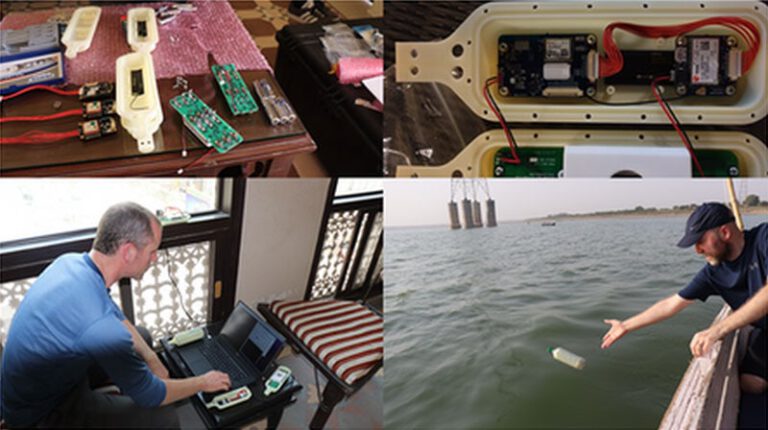
We were tasked with developing a tracker that fitted neatly inside a standard 500ml plastic water bottle. To keep costs as low as possible, we adapted the turtle tracker platform as this was known to be highly effective and very low power.
The tracker needed to perform for 3-5 years following deployment and be tracked in near real time. To communicate the data, we opted for a cellular radio solution combined with an ARGOS satellite radio; this configuration was the optimum solution for a number of reasons, but mainly:
- We needed to have access to communications along the whole length of the Ganges and out at sea
- We needed a much higher location reporting rate throughout the river journey to be able to track it accurately and to understand areas of fast travel and areas of slow travel or when it got stuck
- Reporting rate once out at sea can be relaxed considerably which relaxes the radio throughput requirement
Above is a cutaway section of the tracking device showing the tracker and radio circuit boards mounted along the top of the housing and the batteries installed in the bottom section providing necessary ballast as well as power.
The data was sent to two destinations; when uploaded via the cellular network it was stored on an Amazon Web Services (AWS) Cloud account. As well as being a repository for stored data accessible by all team members around the world, it was also possible to create visualisations which made evaluation of the tracks accessible to all. Data sent over the ARGOS satellite network is destined for the ARGOS proprietary Cloud server. All the data can be automatically extracted from here and presented as a live track in real time, again giving open access to all team members.
Testing
Initial testing was carried out in June 2019 to test the technology. This first involved a lot of experimentation with different SIM cards for the cellular connection before finally launching some of the trackers in the water:
Results

In spite of the cellular antenna being just above the waterline, the performance of the trackers was a great success; the plot above shows how one of the trackers travelled over 300 miles in 8 days.
Not all trackers travelled so far or so fast, often they would get stuck for long periods of time and on the odd occasion also got stolen and were tracked for several days moving around nearby villages before disappearing from the record.

A follow-on trial released some trackers in the Ganges delta in Bangladesh (where the Ganges undergoes a couple of name changes). This particular trial focussed on the ARGOS satellite radio performance and some of the traces of units leaving the delta and entering in to the open sea can be seen above.
These deployments are just a small part of the extensive work now going on to capture the magnitude of the problem with plastic in our environment. The data is helping us to understand plastic flow in river systems and the ocean which goes towards the developing research which can inform governments and institutions and in so doing help them to better tackle the problems. Even having some trackers stolen is informative in helping us to understand the interactions between people and plastic waste.