Overcoming Location and Ranging Challenges to
Maximise Performance
Establishing the absolute location of an object, or the relative position between objects, has many uses and we have delivered technology to carry out these tasks across a diverse range of projects. Here is an overview of some of the location and ranging technologies we are working with.
Global Navigation Satellite System (GNSS)
The ubiquitous ‘sat-nav’ is familiar to most people as a global ability to establish your location and track it in real time. Under the umbrella term of Global Navigation Satellite System (GNSS) there are a number of satellite systems capable of providing highly accurate location services. The first of these to be established was the Global Positioning System, or GPS, which is often the de facto term used for GNSS systems. Today GPS is joined by the Russian GLONASS, Chinese BeiDou and European Galileo satellite systems all providing location and navigation services with further networks promised for the future.

Our projects typically utilise a blend of GNSS systems to get the fastest update of position (the so-called Time-To-First-Fix or TTFF) and the most accurate location. These are the two driving factors in a high performing tracking device and it requires a combination of good RF electronic design, and complex software to optimise each location ‘fix’ and to establish its validity. Careful configuration of device parameters with the use of enhancements from almanac and ephemeris data or other assisting mechanisms provided through cellular or WiFi networks all contribute to a high performing system.

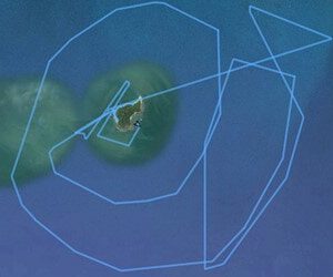
Our expertise in this area has been directed at a number of environmental and conservation projects for tracking animals and environmental waste. These areas are particularly challenging as the tracking device must work in harsh environments and respond very quickly often with a poor view of the sky which limits connectivity with the satellite network. For more information on some of these applications, please check out our case studies which will give further insights into what we achieved.
Ranging, Triangulation and Doppler
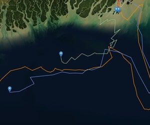
There are other techniques to establishing global location besides GNSS. As an example, we have done a lot of work with satellite communications on the ARGOS network; by sending a transmission from a device to the ARGOS satellite network, the position of the device can be calculated using the Doppler effect on the received signal by the satellites. There are pros and cons to alternative approaches; this solution is not as accurate as a GNSS solution but it can operate with a lower overall power consumption which will benefit battery operated equipment. This makes the ARGOS solution very popular in animal tracking applications, for example. You can read about one of our ARGOS implementations to track replica boats in the Southern Ocean as part of Project Erebus.
Another aspect of location is the positioning of a device from another nearby device, in other words its range. Ranging (establishing range) can be very useful in a number of forms, for example if a shopper walks into range of a particular shop’s WiFi signal, it is possible to push an advert or offer to that person’s phone. Another scenario might be an asset within a company coming into range of a particular Bluetooth transmitter within a building allowing the location of that asset to be established to a relatively small area. Examples of this include a heart monitoring machine within a hospital or a shopping trolley in a supermarket (allowing other services such as promotional messages to be sent to a screen or device on the trolley).
An enhancement to the crude in-or-out of range of a network involves an examination of the power level of the signal received from a device – a higher received power level suggests a device is closer than one which is further away. This method is genuinely useful but can give erroneous readings due to the nature of wireless signals being blocked or reflected by other objects causing power levels to look artificially higher or lower than expected in cluttered environments.

There are more accurate forms of ranging we have designed into projects. We’ve worked extensively with ranging solutions using Ultra-Wideband (UWB) which are based on a wide-bandwidth signal operating in the 2-7GHz frequency range. These technologies can operate over distances up to 150m or so and can be accurate down to a few centimetres. They can use round trip time (RTT) to establish the distance between two objects, a measure of how long a signal takes to be sent by one device, received by a second device, then sent back to the first device. Alternatively, using a fixed array of time-synchronised devices, they can establish the location in free space of a moving object based on the time difference of arrival (TDOA) of the signal at different units in the fixed array. Once the time difference is established, the actual position can be triangulated from the known fixed position of devices in the array.
