The perilous state of the earth’s natural environment is daily news and it would seem we are approaching a point of no return with rising global temperatures, wildlife habitat destruction on an industrial scale and plastic clogging our vast oceans and tiniest cellular organisms.
It is often argued that technology is part of the problem but could it also be part of the solution?
Conservationists and environmentalists around the world are already working hard to curb pollution, stop poaching, close down illegal trade routes, stop habitat destruction, manage farming practices, understand animal behaviours, prevent conflicts between humans and animals, and encourage sustainable land use. The list goes on.
But how do they inform and persuade governments, institutions and individuals to make real and rapid changes? How do they deploy resources to best effect and in a way that gets to the heart of the issues?
These are just a few of the questions that conservationists are grappling with but now, thanks to technology, the answers may be closer than ever.
Data holds the key
Affordable technology has been developed which enables data to be captured in real time and at scale, providing the vital intelligence and evidence needed to make a strong case for change. This technology provides answers to questions, such as:
- Which environments need to be preserved?
- What is the state of health of that environment?
- What animal species use that environment?
- Where do they go?
- What are the threats?
- Are there human threats and if so how do we form a rapid response to these threats (loggers, poachers)?
- How do we track flows of illegal goods around the world?
- How do we monitor the efficacy of existing laws and regulations?
The Role of Wireless Sensor Networks and the Internet of Things
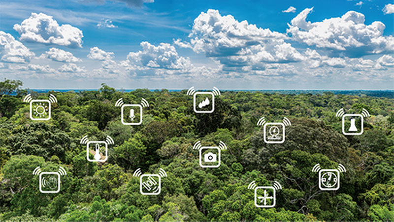
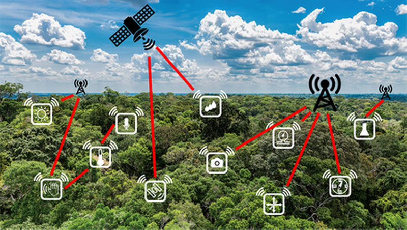
Real time data is collected through “Wireless Sensor Networks” (WSN) and enhanced by greater connectivity to the “Internet of Things” (IoT).
A WSN is exactly what it sounds like, an array of sensors that have the ability to communicate their data wirelessly to another device. To look at this in more detail let’s start with an array of sensors placed at strategic points within the environment.
Common Uses of Sensors
There are many sensors that can be used for many different things; this table outlines some of the more common ones:
ICON |
SENSOR |
Importance |
 |
Temperature | Environment monitoring for trends in global temperature changes of the sea and air
Temperature critical to the survival of species such as coral Polar ice melting reducing habitats for species Animal reproduction can be hyper-sensitive to temperature. For example turtle eggs incubated above 29.3 degrees Centigrade will hatch as females, below 29.3 degrees will hatch as male. |
 |
Audio | Allows us to detect the presence of a species in an area, this can influence conservation efforts
Monitoring of noise pollution, particularly in a marine environment where noise from vessels can disrupt sea mammal communication Identification of gunshots in an area alerting rangers to the possibility of a poaching event underway. Triangulation of the gunshot sound can help pinpoint the location. Identification of chainsaw noise can indicate illegal logging activities in an area |
 |
Chemical | Important for measuring the presence of toxins in an environment, for example as a result of industrial processes
Measuring the salinity of freshwater resources where rising sea levels threaten to contaminate the freshwater table Monitoring concentrations of greenhouse gases in the atmosphere or pH of the oceans |
 |
Light
|
Can play a part in the study of animal behaviours linked to day and night cycles
Infra-red measurements can detect the presence of a human or animal or infer a temperature of a surface Some animals can see in the ultraviolet spectrum |
 |
Humidity | Often measured in tandem with temperature to understand influences on incubated eggs or seed germination |
 |
Global Navigation Satellite System (GNSS)
Also known as ‘GPS’ or ‘Sat-Nav’ |
GNSS allows the position of an animal to be tracked anywhere on the surface of the planet (given a reasonable view of the sky).
Increasingly used to track illegal trafficking of animals or animal products and illegal waste |
 |
Proximity | Presence detection can be used to count passing animals or to activate other monitoring equipment |
 |
Camera | The most powerful sensor available to us. Still images or video enable the presence of species in an area to be verified which can influence conservation efforts.
Animal behaviours can be observed and studied to better our knowledge of them. Presence and identification of illegal activity, people carrying weapons, illegal goods such as ivory or chainsaws suggesting illegal logging activity are invaluable in rapid reaction and holding criminals to account |
 |
Pressure | Particularly useful measuring diving depth for aquatic animals |
 |
Motion | Various motion sensors can be employed to detect movement of animals for behavioural analysis
Equipment can use these types of sensor to only ‘wake up’ when moving thus saving power between any activity of interest. |
 |
Magnetometer | Can be used to detect the presence of metal such as a passing vehicle or even someone carrying a weapon |
Wireless Benefits, Limitations and Options
With the addition of a wireless capability (and a battery or other localised power source) all these sensors can be deployed without cabling (for example, by attaching it to an animal without affecting its behaviour) and the data can be communicated away from the sensor.
The choice of wireless system is highly dependent on the application and there are many options from which to choose. In the first instance, a local wireless connection may suffice in which the sensors can pass data among themselves or to a smart device such as a mobile phone, tablet or laptop. Wireless technologies such as Bluetooth or WiFi are well suited to this and are standard in almost all such devices. This would allow a researcher to collate data or receive alerts from nearby sensors in real time and with minimal costs.
While WiFi and Bluetooth have great utility, their operating range is limited from a few metres to a few tens of metres. To really exploit the power of a WSN, the connectivity needs to be extended to the rest of the world so that data can be stored, accessed, shared and acted on. To do this requires infrastructure of some sort to provide (typically) a longer range wireless link and ultimately a connection to the internet. This connectivity of many devices to the internet and to other connected devices is referred to as the Internet of Things, or IoT. Data storage and processing forms part of the IoT often through the use of vast dedicated servers connected to the internet. These resources can be rented by users as a cost effective way to securely store and share data outside of their organisation and have it readily accessible from anywhere in the world over the internet. The storage and processing services connected to the internet in this way are referred to as ‘Cloud Services’ or simply just the Cloud.
The use of wireless infrastructure (we can refer to this as the ‘Network’) gives us the easiest access to the Cloud from our WSNs. There are many different types available that offer different levels of signal coverage and performance depending on the technology used. A familiar type of wireless infrastructure is of course the cellular network, common around the world. The cellular network is a good example of a terrestrial network that offers excellent coverage in populated areas around the world, though can be absent in extremely remote places and non-existent at sea. Data rates are good, allowing large amounts of data (such as images or videos) to be sent quickly and reliably to the Cloud. For truly global coverage, satellite infrastructure can provide internet access to the Cloud from anywhere on land or the surface of the sea, so long as a good view of the sky can be achieved. The downside with satellite communications though are that the data rates tend to be quite low, therefore being best suited to transmitting small amounts of data such as an alert, a temperature measurement or a GPS location.
We can see that the network is the real enabler of IoT but the choice of wireless technology is crucial to its performance. Anyone wishing to deploy an IoT enabled WSN will need to carefully balance a number of commercial, functional and technical aspects in choosing the right wireless technology to ensure their network is viable.
Four key metrics related to the wireless technology are as follows:
- Cost
- What are the costs required to develop a device that can connect to the network? How much will it cost to utilise the wireless network (contract, pay as you go, pay per use etc)
- Availability
- Does the area in which you want your WSN to operate have any existing commercial network coverage, and if not, is it possible to roll out your own network in the area?
- Range
- How far away will your WSN be from the network?
- Bandwidth or data rate
- How much data do you need to send in any message and how quickly does it need to be transmitted? Camera images or video will require significant bandwidth while a single GPS location will require very little.
It should come as no surprise that the metrics highlighted above all trade off against each other; if you want longer range, you usually get lower data rates. If you want higher data rates or greater coverage your costs usually get higher.
For truly global coverage, albeit typically with low data rates, a satellite based system would be desirable such as Iridium and ARGOS (with newcomers such as Lacuna Space, Hiber, ICARUS and others emerging on the scene). With coverage constrained to land and with notable gaps in remote or rural areas, systems such as cellular (GSM/UMTS/LTE/5G), Sigfox, LoRa, LoRaWAN, ‘sub-GHz’ and many others can be utilised offering considerable flexibility.
To summarise the relative capabilities of some of these technologies, the following chart aims to visualise maximum data rate versus maximum connection range.
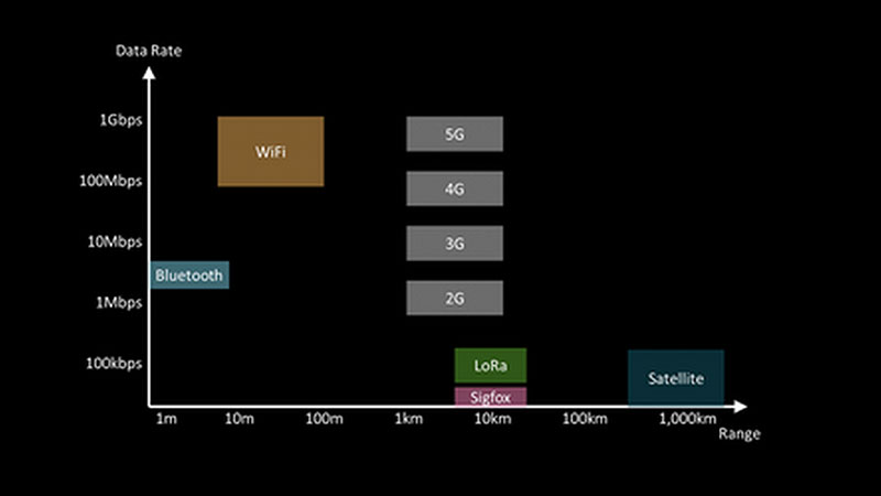
In a large IoT network, it is not necessary to take a one-size fits all approach; it is entirely possible to use different networks to connect your devices to the Cloud on a case by case basis. Devices can ‘mesh’ together where one device may pass its data to another device that has a connection to the network; some devices may connect directly to a satellite network and some may connect directly to a terrestrial network.
Once the data is in the Cloud it doesn’t matter how it got there, it becomes a global resource on the internet.
Data sets feed in to:
- Reports for governments, global institutions and non-governmental organisations
- Research programmes aiming to understand animal behaviours so that they can be protected
- Instant alerts can communicate in real time to rapid reaction forces combatting illegal activities such as poaching and smuggling
It can therefore be seen that the mass collection of data from WSNs around the world, even if focussed on a narrow area of study, can feed up in to a global resource of information that can be acted upon in the moment or fed in to bodies that have the power to act and legislate on this information and flow down the responses that are required to save the planet.