Icoteq launch TagRanger® System of products
TagRanger® is a state-of-the-art wildlife finding, monitoring and tracking solution for research, conservation and environmental professionals.
With superior configurability for logging data, reporting location and engaging in GPS-beating ranging technology, TagRanger® will direct you to the exact Tag location with a precision that gets you within touching distance (‘Finding’).
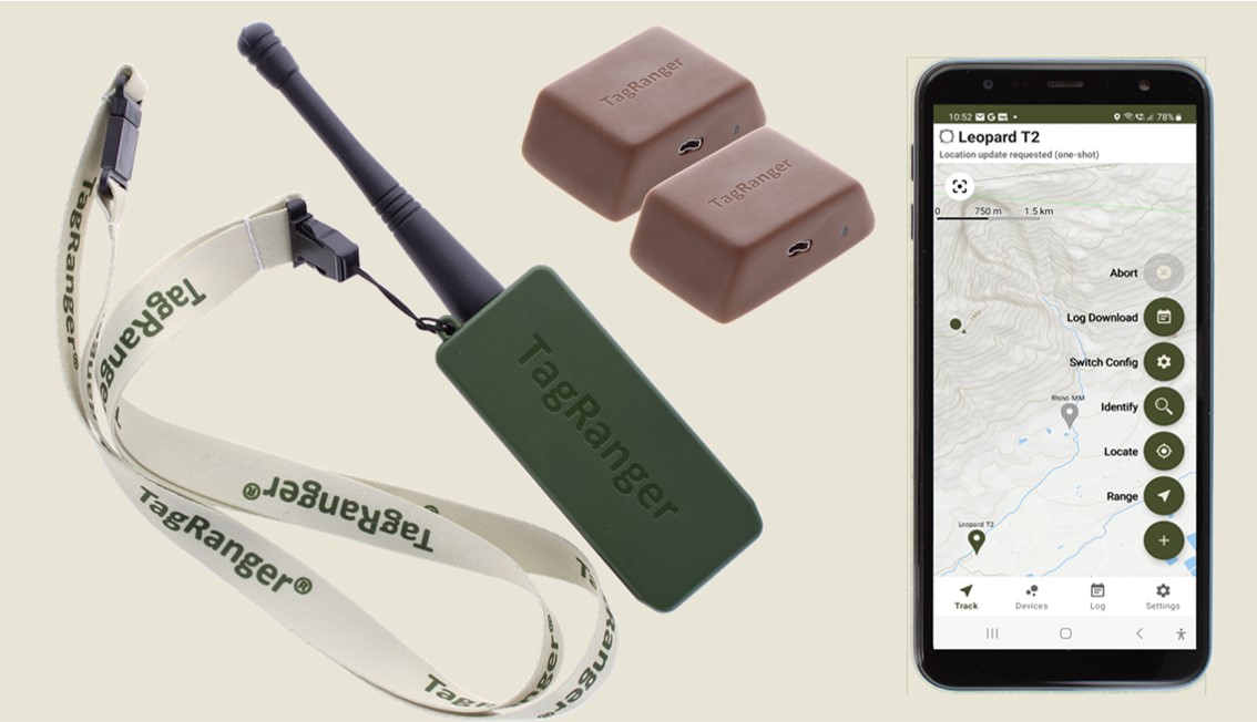
A TagRanger® system has three elements:
- A Tag. A small device to be fitted to the animal or equipment you want to monitor.
- A ‘Finder’ device. A small handheld device paired with your smartphone. The Finder device is a LoRaWAN gateway and is used to manage and communicate with your Tags. It can also be left to gather data from your Tags to be retrieved at a later date.
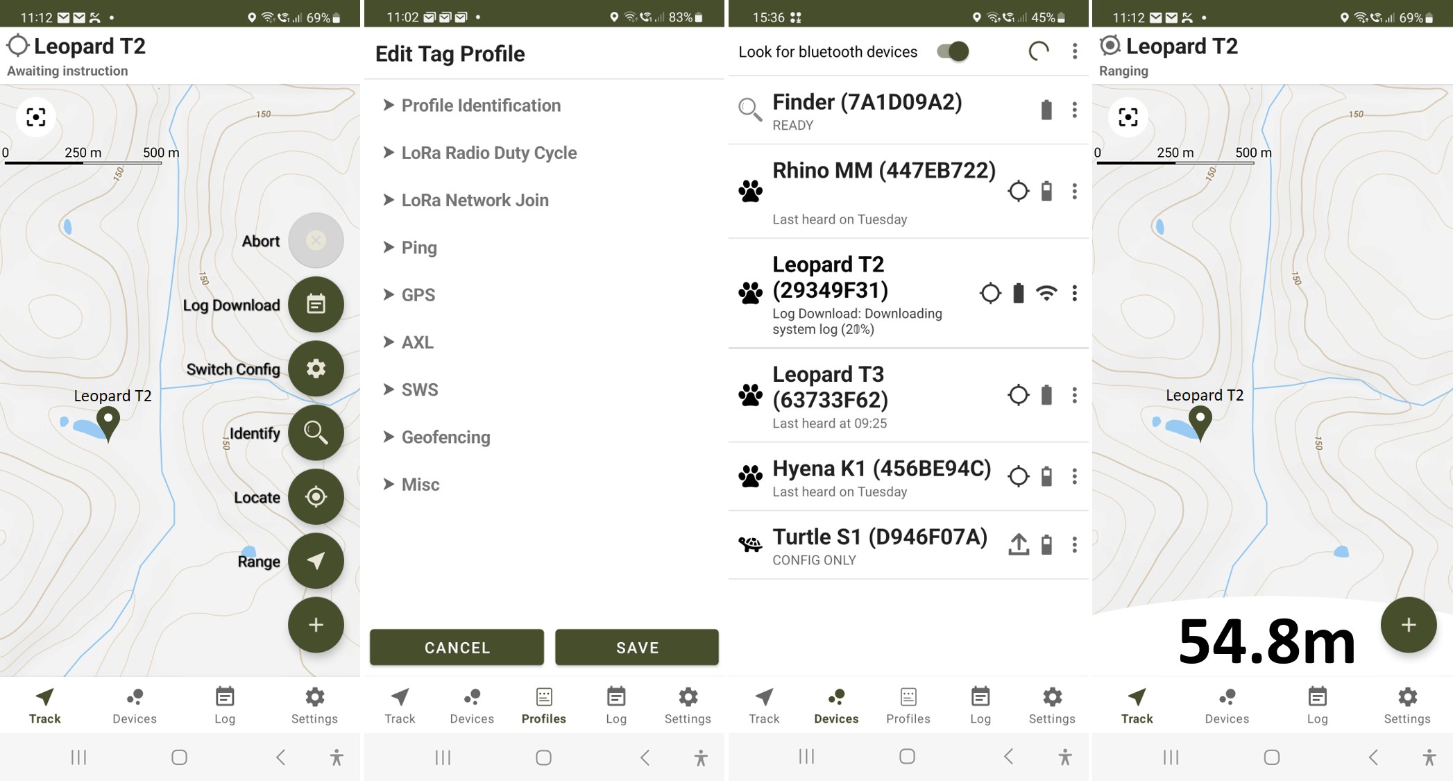
- TagRanger® App. This powerful app runs on your Smartphone and connects with the Finder device. It provides the configuration and operation interfaces with your Tags, as well as displaying both online and offline mapping for your Tag locations.
TagRanger® offers cloud-less operation with the ability to work entirely offline with no network infrastructure or subscription costs. If you already have your own private LoRaWAN network in operation, TagRanger® can seamlessly integrate into that system too.
Overview
TagRanger® sets a new standard in wildlife monitoring and tracking, using advanced sensors and a unique combination of:
- GNSS (satellite-based location services including GPS, Gallileo, Beidou, GLONASS)
- UWB (Ultra-Wideband) for ultra-precise distance measurement (‘ranging’) from a few centimetres up to 150m (line of sight)
- LoRaWAN (Long range radio) for long distance communications in the 868MHz and 915MHz frequency bands
Low-cost, rechargeable Tags with exceptional power efficiency ensure long deployment life and higher Tag reuse.
Extended range capabilities are possible through a TagRanger® Relay device mounted on a drone or in a fixed location, enabling real-time tracking and data collection in large territories, dense canopies, and challenging landscapes (future development).
Applications
Locate on Demand
Using the TagRanger® App with the Finder device, you can remotely request any TagRanger® Tag to report its GPS location on-demand. This unique remote wake-up feature allows you to receive real-time GPS location updates from the Tags, providing crucial insights into the location and movement of animals.
Finding Tags
Sometimes it’s not just enough to know where your Tag is, but to actually find it for a number of purposes such as:
- Close observation of an animal
- Animal intervention such as a veterinary procedure
- Download of large datasets from Tag
- Tag recovery for recharging or replacement
- Wildlife filming
With TagRanger® you can find your Tag using a combination of LoRaWAN, GNSS and UWB. Once you have carried out a ‘Locate on Demand’ as described above, you can go to the GNSS location to start your search. If you are in range, the UWB measurement capability can then be used to give you a precise distance to the Tag, so even if you can’t see it, you can home-in until you are close enough to touch. This is also a good way of distinguishing between several Tags in close proximity (for example, turtles on a beach or deer in a herd).
This capability can also be utilised on equipment! If you have a remote camera camouflaged at a location and a user unfamiliar with the hiding place was sent to service the camera (replace batteries, retrieve memory card), they could use the Finding capability to discover the camera quickly, even in the dark.
Animal Tracking
Traditional animal tracking can be carried out using TagRanger® which can track the location of your Tags. GNSS locations are updated automatically according to your own preset schedule and stored on the Tag. You can choose whether to transmit each location as it is acquired (live tracking) or download them at a later date.
Data Logging
All data from the GNSS, temperature sensor and accelerometer is logged on the Tag for download when you choose. A total capacity of up to 2MB ensures there is plenty of storage for extensive data sets. The data can be downloaded using the UWB radio interface when you are within 25m of the Tag or using the Bluetooth connection if you have recovered the Tag.
Key Features
- Finding: TagRanger® offers precise finding with its unique combination of GNSS, UWB, and LoRaWAN technology. Users can remotely wake up a Tag device from a ‘Finder’ device using LoRaWAN to request GNSS location and when close, use the UWB technology to ‘home in’ on the Tag over a range of up to 150m.
- Tracking: GNSS locations can be logged on a customised schedule to internal storage or transmitted in real time over the LoRaWAN long range radio.
- TagRanger® App: Runs on an Android smartphone and is paired with a ‘Finder’ to provide Tag communications, Tag management, mapping (online and offline), Tag notifications, configuration settings, and warnings. Download from the Google Playstore.
- Highly Power Efficient: TagRanger® stands out for its exceptional power efficiency, allowing it to operate for up to 4 years before requiring recharging (subject to the configuration profile).
- Rechargeable Tags: Tags can be recharged using a MicroUSB cable and used again.
- Cloud-Less Operation: TagRanger® is a cloud-free solution, operating without the need for constant internet connectivity or cloud infrastructure. This feature ensures reliable tracking and management even in remote areas.
- Extended Range with Drone-Enabled Multi-Hop Communication: Mounted on a drone or other fixed infrastructure a TagRanger® Relay device extends the range capabilities beyond the standard LoRaWAN technology. This multi-hop functionality ensures comprehensive wildlife monitoring across larger territories and challenging landscapes (future development).
- Temperature Sensor: The integrated temperature sensor provides valuable environmental data, enabling researchers to assess wildlife habitat conditions accurately.
- Accelerometer for Activity Detection: The built in accelerometer can be used for motion alerts (mortality/dropped Tag events) or monitor activity patterns, contributing to in-depth behavioural analysis.
- Remote Data Download: The UWB technology allows for high-speed and non-intrusive data download, ensuring efficient recovery of dense data sets without disturbing wildlife. This can only be used within 25m of the Tag.
- Remote Configuration Update: Change the configuration of a Tag remotely using the LoRaWAN long range radio.
- GeoFence: Set up to 5 geofences where transmissions are either enabled or disabled depending on your requirements.
- Secure: All TagRanger® long range radio communications are encrypted meaning your data is secure from eavesdropping.
- Integrations: TagRanger® can be seamlessly integrated in to your own private LoRaWAN network.
Customisations
TagRanger® is designed to be highly configurable and extensible and many new use cases can be customised through software alone. The core electronic hardware can also be used as a platform to add features such as additional radio modules (satellite, cellular etc), alternative sensors or battery charging technologies. This means a custom solution to your tracking/monitoring requirements can be achieved at a much lower cost than a completely new design.
The UWB radio technology is a particularly interesting area for customisation; given the ability for very accurate distance measurement up to 150m this can be adapted for proximity warnings in human/animal conflict avoidance or to establish proximity between specific animals to monitor likelihood of mating or fighting scenarios. These can be further enhanced by advanced accelerometer algorithms to determine the interaction in detail.
Using UWB measurements from multiple fixed locations to a single Tag allows very precise positioning to be established through triangulation, and through this it is possible to track animal behaviour within a defined enclosure (such as in a zoo or corralled area). This data can be highly insightful to monitor animal well-being for example.
For any customisations, please contact Icoteq to discuss your requirements.
Summary
TagRanger® stands as a game-changing solution for wildlife monitoring and protection, providing real-time data and insights to aid conservationists and researchers in their efforts. Its unique combination of GPS, UWB, and LoRaWAN long-range radio technology, along with drone-enabled multi-hop communication, advanced sensors, cloud-less operation, and exceptional power efficiency, enable organizations to carry out cost-effective informed monitoring and take proactive measures for wildlife preservation.
Working With Us
As a technology consultancy, Icoteq can offer competitive pricing for customisations of the TagRanger® baseline system. This platform allows for the addition of new sensor technologies and radio solutions, providing researchers with the flexibility to tailor TagRanger® to specific research needs.
Icoteq have many years of experience working with animal conservation and environmental organisations, with notable projects under our belt with National Geographic, Zoological Society of London, WWF and Arribada Initiative to name but a few.
Join us in our commitment to wildlife conservation and research with a TagRanger® solution today. For further information or to schedule a demo, please contact our sales team.
